Tag Archives: California

Six Nerdy Population Factoids

If evenly divided, the $787 billion stimulus package could make everyone in South Dakota a millionaire.  (They’d each get $978,619.59, actually).

There are more Californians (36.76 million) than there are Canadians (33.56 million) plus Alaskans (686,000) combined.  There are also more Californians than there were Americans at the time the Civil War broke out (31,443,321 in the Census of 1860).

There are more people in Los Angeles County (10,363,000) than there are in Michigan (10,003,000) , which is the 8th most populous state.

There are more people in Brooklyn plus Queens (4.8 million combined) than in Montana, Wyoming, North Dakota, South Dakota and Idaho (4.467 million combined).

The eight southwesternmost contiguous states — CA, AZ, NV, UT, NM, CO, TX and OK — contain 24 of the 50 largest US cities.  Actually, Utah doesn’t have any and Honolulu is one, so in a convoluted sense, exactly half the biggest cities are in the southwest.

Since 1980, Nevada has grown by 4.3% annually.  Worldwide, this level of growth would be both crushing and unsustainable over that long of a time frame.  Even impoverished Third World nations where women are treated like birthing machines don’t see rates like that, which is due to huge numbers of people migrating to Nevada.  Depending on who’s counting, only one country in the world is growing more quickly.  It would be either Liberia or the Maldives, and ironically the Maldives will be the first country to disappear when the oceans rise, since it’s highest point is only 2 meters above sea level).

If this trend were to continue, Nevada’s present population of 2.6 million will double in just seventeen years (2026).  It would exceed 15 million by 2050, 35 million by 2070, and 300 million by 2123. Fortunately, Nevada inhabits a harsh desert and has many natural predators.

El Camino Real: Your Gateway to the Peninsula’s Tackola Marvels

I’m sure it dates from Spanish times, since it means “The Royal Road,” and doesn’t seem to be a post-meaning place name chosen to connote aristocracy or California-ness like so many other places.

Here are some shots of the Bay Area’s equivalent to Nassau County, New York’s Old Country Road, Seattle’s Aurora Blvd or Austin’s North Lamar and Burnet Roads.

dsc_0212

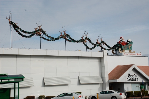
Xmas at the candy factory.

dsc_0213

This reminded me of a Valentine’s Day episode of Sprockets on SNL in its early-90s heyday when first prize for competing in Love Werks was dinner at the House of Knives followed by a night at “Potato in Chainmail.”

dsc_0221

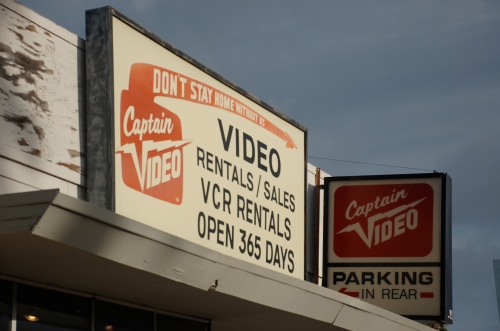
Photograph your local video store now.  It might not be there when “He’s Just Not That Into You” comes out on DVD.  Don’t wait till golden hour–do it now.  Captain Video (Captain Eo?) refers to a mid-80s AmEx slogan.  Amazing.

dsc_0217

I bought my boyfriend some Valentine’s Day chocolate from this place.  It was decidedly gaudy.

dsc_0211

I heart bowling alleys.

dsc_0207

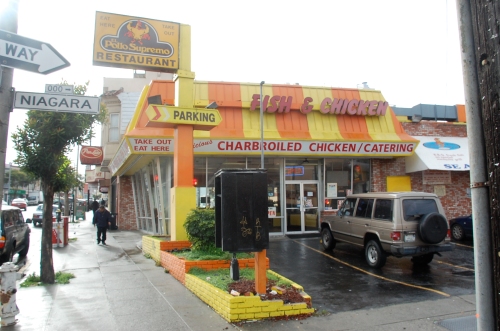
This is actually in San Francisco proper, but it was just too darling to leave be for purity’s sake.  I can’t vouch for the chicken’s supremacy but brightly painted bricks are pretty rad.

Two Potential Road Trip Routes

In pursuit of reaching all 50 states before I’m 30 (as I promised I would do when I was 20; seven to go), here are some road trip itineraries.  Not that they go to that many states, but I want to go everywhere.

picture-22

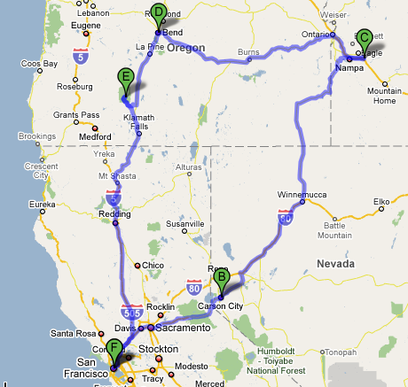
S.F. – Carson City/Reno – Boise – Bend, OR – Crater Lake – S.F. At 1500 miles, this would take 28 hours of driving.  Which means you would do it in five days, six if you stayed in Crater Lake an extra day.  (Bend is where the Thomas Beatie, the Pregnant Man lives.  He had the baby and is pregnant again.  I would like to drive there and tell him how I support his radically normal agenda.)

picture-33

S. F. – Yosemite – Kings Canyon/Sequoia Nat’l Parks – Death Valley – Las Vegas – Joshua Tree – Coastline – S. F. This one would be way longer.  It’s 1600 miles plus adventures within the national parks, but a lot of it is windy backroads.  Especially the last leg, going up the coast on 1.  It wouldn’t be quite as terrifying to do that drive at night as it is to come south, because the Pacific isn’t right below you heading north, but it would take an eternity.  An amazing eternity.  And by going to Death Valley one simply must visit the Amargosa Opera House in Death Valley Junction.  Not that I have yet.

The Penny Saver Inn

dsc_0045

This was the last night on our three week road trip before reaching San Francisco.  It’s Crescent City, CA, which I thought would be bigger, although the houses have a sort of Bermuda feel to them.  They’re small, neat, close together and pastel.  (I only took pictures during golden hour, when pastels don’t always shine through.)

Crescent City, not too cute that it’s got bed and breakfasts littering everything, has a spectacular coastline but the only thing to eat at 8pm was a $5 Subway foot-long, the existence of which prevented us from eating burgers every night for 3 weeks.

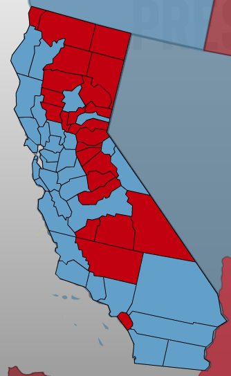
Interestingly, Crescent City is the seat of Del Norte County along the Oregon border, the “Northern Gate to the Golden State,” which was the only coastal California county besides Orange County to prefer McCain to Obama.  (The three SW-most counties on the Pacific in Oregon were also red; from there north, it’s a line of blue straight up to Canada).  Of course, it only has a population of 27,000, making it the least populous coastal county in the state.

picture-3

Seems to me that the relevant political dichotomy of California (with the exception of Orange County) should be Coastal vs. Inland, rather than North vs. South.  But what do I know–I just moved here.

In any case, it’s way pretty and shit.