Tag Archives: Nerdy Maps

Vaginas in Government!

The states that have had female senators, color-coded by party (NC being the only state to have elected women from both):

picture-1

The states that have had female governors, again color-coded by party, although NC is turquoise for some curious reason known only to Wikipedia:

picture-2

However, a lot of these women have been appointed, usually when their elected husbands died.  This typically happened in the dark old days, which is to say, from the period when the earth cooled until approx. 2002.  In fact, of the 37 women ever to have served in the US Senate, only 23 were elected in their own right.  Of those, 16 are there today.  (Would be 17 out of 36 if Hillary were still there).

These are the states that have elected women to be governors-or-senators, both or neither.
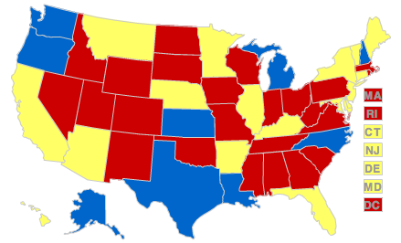
picture-3

Not much of a geographical pattern.  I have to say I’m surprised about Alaska.  Its politicians tend to stay in office forever and it’s only been a state for 50 years (same goes for Hawaii, on both counts) but it has Gov. Tina Fey and Sen. Lisa Murkowski–appointed by her dad but then later elected.  Say what you will about Sarah Palin, but there are very few women who have been elected to high office without being related to a powerful male politician.  (Todd’s relationship to the Alaska Independence Party notwithstanding).

Almost every state has elected women to the House.  The exceptions are mostly tiny states with few congressional districts, such as Vermont and North Dakota.  There are only two states that never, ever had a woman serve as a governor, a senator or a representative: Mississippi (shocker) and Iowa (shocker; non-sarcastically).  But both have had female lieutenant governors, and that’s the real money-maker.

On the other end, both Maine and California have two female senators.  Maine is the only state to have elected three women to the chamber.  And California has Nancy Pelosi, too.  Washington State is a goddamn vaginocracy, with both senators and its governor being women.  Awesome!

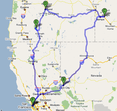
Two Potential Road Trip Routes

In pursuit of reaching all 50 states before I’m 30 (as I promised I would do when I was 20; seven to go), here are some road trip itineraries.  Not that they go to that many states, but I want to go everywhere.

picture-22

S.F. – Carson City/Reno – Boise – Bend, OR – Crater Lake – S.F. At 1500 miles, this would take 28 hours of driving.  Which means you would do it in five days, six if you stayed in Crater Lake an extra day.  (Bend is where the Thomas Beatie, the Pregnant Man lives.  He had the baby and is pregnant again.  I would like to drive there and tell him how I support his radically normal agenda.)

picture-33

S. F. – Yosemite – Kings Canyon/Sequoia Nat’l Parks – Death Valley – Las Vegas – Joshua Tree – Coastline – S. F. This one would be way longer.  It’s 1600 miles plus adventures within the national parks, but a lot of it is windy backroads.  Especially the last leg, going up the coast on 1.  It wouldn’t be quite as terrifying to do that drive at night as it is to come south, because the Pacific isn’t right below you heading north, but it would take an eternity.  An amazing eternity.  And by going to Death Valley one simply must visit the Amargosa Opera House in Death Valley Junction.  Not that I have yet.

Google Map of the 2008 Road Trip

It took longer than I thought (the google map; not the trip), but here it is.  Green flags are places we stayed, and pink is for random oddities.

Bubonic Wal-Mart

Watch the eerie green pandemic spread from Patient Zero in the Ozarks.

Little-Known Falsehood: In only four years, from 1347 to 1351, Wal-Mart decimated the population of Europe, leading to panic, religious revivals and the specter of Death playing chess across Scandinavia.

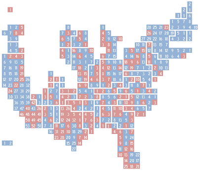
Nerdy Map! And a nerdy look at the future.

I’m going to come in my pants, Nate Silver!

picture-12It’s the congressional districts of the US, colored by which party holds them (duh; obv).  If you read the post, he even has a cute little bit about how he tried to make it pretty and accurate and shit.
Secondly, the 2010 Census reapportionment that once looked bleak for blue states–with even California losing a seat to the ever-burgeoning Sunbelt–might be a little better, as the Depression seems to be rendering people immobile.  Not something to celebrate, but still.

New York and Pennsylvania continue to hemorrhage seats, and on the whole it’s the red states who are gainers, but of course some former red states have purpled.  And the trend towards purpling owes itself partially to migration patterns; i.e., “liberal” northeasterners have made North Carolina bluer as Californians have transformed Nevada.

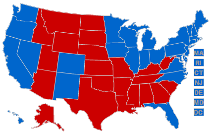
Obama won 365-171.  If he were to reproduce those results by state in 2012, there is a spectrum of vote outcomes based on the reapportionment.  Taking 538’s analysis, this map (which excludes the 1 Nebraska vote Obama won)

picture-13

If the projections fall on the low end, that 364171 victory will be 357188.  If they fall on the high end, it would be 345190, which is 48 points closer than the ’08 election.  This assumes demographic changes won’t propel Missouri, Texas or Montana into the blue category.

Running Gore’s 271267 loss through two waves of reapportionments (that is, 2000 and 2010) results in a bloodbath.  It would have become 278260 in 2004/2008 and in 2012 could well have been as bad as 298240.  This built-in demographic disadvantage got no play in the media that I can recall and makes the Dems success even starker.

An only slightly less nerdy map, but still…

picture-51

…who knew that a state’s natural beauty correlated so well with the manufacture of good beer?