Tag Archives: Road Trip ’08

Google Map of the 2008 Road Trip

It took longer than I thought (the google map; not the trip), but here it is.  Green flags are places we stayed, and pink is for random oddities.

Two from Wyoming

In honor of the least populous state, home of Dick Cheney and a massive McCain landslide over Obama, here are two of my favorite photos from there.

Bosler, Wyoming.  September 2008.

Bosler, Wyoming. September 2008.

I made us turn around and stop when we passed this time-warp.

Moorcroft, Wyoming.  September 2008.

Moorcroft, Wyoming. September 2008.

If it’s hard to go long without eating burgers on a road trip, it’s even harder to avoid big breakfasts with pancakes, eggs, lots of coffee, etc.  Donna’s was one of the good ones.  The waitress, who called us “Hon,” almost added coffee to Elliott’s tea.  We each had a bit of a cold from camping out near the foot of Devil’s Tower the night before–which was totally a highlight of the entire three weeks. I know this photo isn’t a particular knockout, but it crystallizes an interesting moment.

The diner was panelled (fake, naturally), had a room in the back for special events, and a group of six or eight Mormons guys our age came in and prayed over their breakfast.  And people were smoking in there, which feels like a complete throwback by now.  Moorcroft is a small town, maybe 600 people, and there’s not much around  but beautiful country.  Devil’s Tower shows up a lot as a motif, but I don’t think they get too many tourists.  That was one of the best places.

The Penny Saver Inn

dsc_0045

This was the last night on our three week road trip before reaching San Francisco.  It’s Crescent City, CA, which I thought would be bigger, although the houses have a sort of Bermuda feel to them.  They’re small, neat, close together and pastel.  (I only took pictures during golden hour, when pastels don’t always shine through.)

Crescent City, not too cute that it’s got bed and breakfasts littering everything, has a spectacular coastline but the only thing to eat at 8pm was a $5 Subway foot-long, the existence of which prevented us from eating burgers every night for 3 weeks.

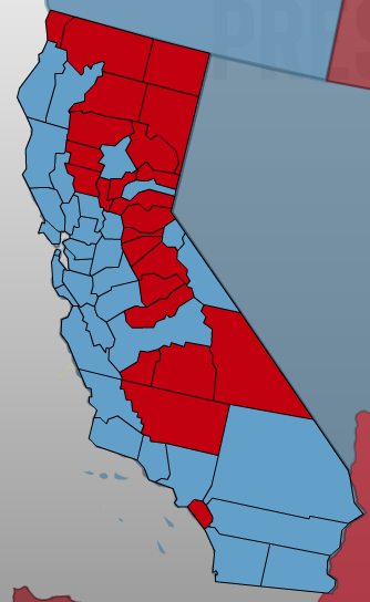
Interestingly, Crescent City is the seat of Del Norte County along the Oregon border, the “Northern Gate to the Golden State,” which was the only coastal California county besides Orange County to prefer McCain to Obama.  (The three SW-most counties on the Pacific in Oregon were also red; from there north, it’s a line of blue straight up to Canada).  Of course, it only has a population of 27,000, making it the least populous coastal county in the state.
picture-3

Seems to me that the relevant political dichotomy of California (with the exception of Orange County) should be Coastal vs. Inland, rather than North vs. South.  But what do I know–I just moved here.

In any case, it’s way pretty and shit.

Spiral Jetty

Promontory Point, Utah.  September 2008.

Promontory Point, Utah. September 2008.

This was sort of the culmination of our road trip, the capstone of remote and gorgeous Americana. Robert Smithson’s 1970 earthwork sculpture has only been exposed from the Great Salt Lake for a few years after a decades-long period submerged. As we were there at the end of the summer, the lake’s edge was actually two hundred yards beyond the sculpture. What looks like whitish water here is deposits of salt. The border between lake and shore is more indistinct than any other sizeable body of water that I’ve seen; the shore is pure crystalline salt, strange underfoot, and gradually becomes more more and more moist as you approach the lake proper. I guess the lake is probably super-saturated and exists beneath the salt along the shore. Amazing.

We had the site to ourselves for the entire two hours we were there, and passed two vehicles arriving as we were on our way out. It was a hot afternoon, our water was hot in our bottles, and the weird and silent terrain was magnificent. It takes forever to drive there–at least an hour from Golden Spike National Historical Site, 12 miles away–because you have to keep below 10 mph on roads that are not only unpaved but have basically been cleared only of boulders. There was no sign of human civilization, not even a radio tower, to be seen. You get a good grasp of why the original Mormon settlers could have felt convinced of their relationship with the Israelites. That part of Utah looks like Judaea, by the Dead Sea.

I picked up a small rock from around the Jetty and threw another one from the hillside to balance it out. Elliott took a naked Polaroid of me and I actually like it. Trying to think of a more ambitious place to reach by car, there’s nothing that comes to mind. After the shithole that was Salt Lake City (where I was yelled at in a motel parking lot by a woman pushing a shopping cart out of her room) it couldn’t come at a better time.

Behold, the Atom [No Vacancy]

Atomic City, Idaho is a profoundly scary place two miles off the highway.  With at most 25 people in it and no open stores, it really couldn’t be less of a city.  We drove around it, took a Polaroid and got the hell out before something ate us, because it’s probably been the home of giant mutated ants since 1956.

However, Arco, which is a sizeable and picturesque town at the foot of the mountains, seems to be thriving.  If it were to experience some soil subsidence and just sink by 40 feet, it could elbow Denver out of the way and be the New Mile High City.  I especially love that City Hall has a sign that could be for a motel:

dsc_0100

Some Ambient Retardation

Seattle, Washington. September 2008.

Seattle, Washington. September 2008.

This photo was taken by my canine companion, Woofgang Amadoggus Mozarf on our way from New York to California.